 Where I camped:
Movie Road in the Alabama Hills
GPS: 36.627712, -118.126411
Elevation: 4789′
Get Directions
The Alabama Hills are my favorite place to camp in all of California. Picture a majestic, other-worldly expanse of massive granite boulders nestled right at the foot of the Sierra mountains. The sites are fairly spread out, so you’re not camping right on top of your neighbor. Glorious views of Mount Whitney, the tallest peak in the lower forty-eight.
Tip: Rise and shine by sunrise to see the Sierras light up in orange, red, and purple hues.
Where I worked:
McDonalds
601 S Main St
Lone Pine, CA 93545
If you can tolerate the screaming children and high pitched BEEP!!s from the coffee machines (headphones were a saving grace), this was a great place to work. Free, high-speed wi-fi and plenty of seating with power outlets. In late Spring and early Summer, this joint is packed to the brim with PCT hikers.
Alabama Hills Cafe
111 W Post St,
Lone Pine, CA 93545
I looooooove this place! Strong wifi, outlets by a few tables, and it’s right next door to the laundromat – so I could do laundry while I worked. The only downside is that the restaurant is mighty small, and one of the waitresses had to kick me out during the lunch rush to make room for other customers. Otherwise I would have spent all day everyday here!
Where I hiked:
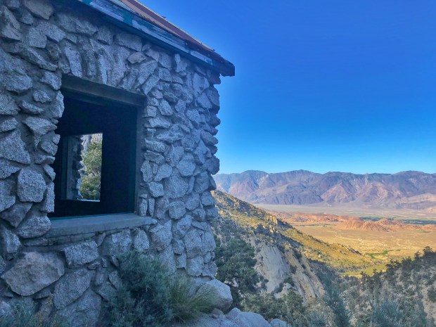 Tuttle Creek Ashram
Distance: 3.5 miles round trip
Time: ~2 hours
Elevation gain: 1432 ft
This hike leads to a beautiful, albeit slightly eerie abandoned stone building that served as a spiritual respite for theosophists in the 1930s. Tucked away in a glacier-carved canyon, the ashram is situated just above a small waterfall and overlooks the Owens Valley and Inyo Mountains. You’ll gain a fair amount of elevation in the first mile, but it’s well worth it. Beautiful desert flowers along the way.
Tip: Park on the dirt road about a mile before the trailhead if you don’t have four-wheel drive.
 Kearsarge Pass Trail
Distance: 11 miles round trip
Time: ~5 hours
Elevation gain: 3474ft
What. A. Hike. Photos just don’t do it justice. Sweeping views of the Sierra Crest and pristine lakes in all directions. The trail weaves through alpine tundra, forests of pine, slopes covered in manzanita, and boulder fields. It’s an entry / exit port for many a PCT and JMT hikers, so you’ll likely get asked for a ride back down to the highway. They’re a friendly, albeit smelly bunch. 😉
